We'll start November with a front that will bring rain and lower temperatures
We're going to have a change of weather on Saturday, a front is coming to us, and in the afternoon we're going to have rain and maximum temperatures are going to go down.


The pleasant weather of the last few hours will change with the new month. With November a front will arrive that will rain and temperatures will drop.
On Friday we shall have more cloud cover than on Thursday. Medium, high and clear clouds will alternate. The cloud cover will mostly be concentrated in the west, and it is not ruled out that there will be some drops in the morning. In the afternoon it is more likely to rain and there may be some more intense rain.
On Saturday we will be hit by a front. In the morning the southwest wind will blow proud and barely rain. In the afternoon, however, the wind will turn west/northwest and start to rain. It will rain mostly in the west, with the possibility of some more intense showers. The maximum temperatures will drop, especially in the afternoon, then the wind will settle and cool from the northwest.
On Sunday the atmosphere will be cooler. The temperatures will drop, the highs will be around 14-16 ° C in the interior and 17-18 ° C on the coast. The skies will be very cloudy and there will be showers, more frequent in the north half and in the morning.
You might like

Do you know why bright colors dye the sky?
The usual phenomenon is the one that occurs all year round. Today, the conditions are in place to be able to observe it: the southern wind and the high clouds.

No wardrobe changes, for now
The southern wind will warm the atmosphere from Tuesday, although it will also bring some rain. Temperatures above 20 ° C are expected for next weekend.

Ezegonkortasuna eta tenperatura freskoak izango dira nagusi urriko azken asteburuan
Astean zehar izandako tenperatura altuen ondoren, asteburuan fresko izango dugu eta zenbait tokitan termometroak ez ditu 15 ºC-ak gaindituko.
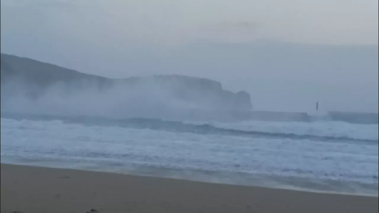
The Benjamin blur has caused waves more than five meters high on the Basque coast
As measured by the weather stations of Euskalmet, strong winds are being recorded at 146 km/h (Matxitxako), 120 km/h (Santa Clara, Donostia) and 117 km/h (Punta Galea), among others.

News: Benjamin blurring, warning in the livestock sector and the 45th anniversary of the Ortuella tragedy
A summary, in two words, of what will be news in the Present today.

A blur will cause winds of more than 100 km/h and waves of more than 5 meters
On Thursday, the Basque Government's Department of Safety will activate the yellow wind warning and the orange wave alert. On the other hand, the Aemet will activate the yellow wind warning in northern Navarre and the Ribera. In addition, the Meteofrance has announced an orange wind and wave alert in the Atlantic Pyrenees that includes Iparralde.
Autumn atmosphere and showers to start the week, breaking the trend of the last few weeks
On Monday the sky will be cloudy and there will be some showers, especially along the coast, and Tuesday will be similar, but on Wednesday the clouds will become cloudy, the sun will rise and temperatures will rise.

Comet Lemmon, 1,350 years later, again visible
The comet Lemmon can be seen again from Earth after 1,350 years of orbit. The last time it was seen from Earth was in the 7th century. Next Tuesday will be the closest day to Earth, 89 million kilometers.

The weekend will begin with the sun and on Sunday there may be weak rain on the cantabrian side
On Friday and Saturday sunny weather will prevail, but on Sunday the clouds will return and there will be weak rain on the cantabrian side.